Lago Di Sorapis Hiking Guide: Passo Tre Croci to Sorapis
Originally Published January 2025, UPDATED MARCH 27th, 2026
Lago di Sorapis is one of the most famous hikes in the Dolomites, known for its unreal turquoise water and dramatic mountain backdrop. But here’s what most photos don’t tell you: the hike from Passo Tre Croci to Lago di Sorapis is moderate, exposed in sections, extremely popular in summer, and requires proper preparation, especially if you’re hiking solo or visiting Cortina d’Ampezzo for the first time.
I finally hiked this trail after years of seeing the lake online and spending countless weekends exploring the Dolomites from my home in Vicenza. And while the lake really is as blue as everyone says, the journey to get there is the part that travelers underestimate most.
This guide gives you the practical information I wish I had before I went:
- the real difficulty level (not the sugar-coated version)
- How long does the hike actually take
- What the exposed ledges and cable sections feel like
- The best time of day to start—if you want fewer crowds and safer conditions
- whether to drive or take the Dolomiti Bus to Passo Tre Croci
- And why you should download Komoot offline maps before you step onto the trail
This Post Pairs Well With:
- A First Timer’s Guide to the Dolomites
- Hikes Near Cortina d’Ampezzo: 5 of the Best Scenic Trails
- Where to Stay Before & After the Alta Via 1: A Solo Hiker’s Guide
- Is Cadini Di Misurina Worth the Hike?
Lago Di Sorapis at A Glance
Lago Di Sorapis
- Trail Head Start: Google Map Pin
- Length: 11 km
- Difference in altitude: 300 m
- Minimum altitude: 1805 m
- Maximum altitude: 1926m
- Travel time: 4 hours
- Difficulty: E (hiking) with some exposed sections
- CAI trail sign: 215
- Tobacco map n° 3
- Water: Vandelli Refuge
Why Hike to Lago di Sorapis in the Dolomites?
Most people hike to Lago di Sorapis for the color alone, and honestly, it lives up to every photo you’ve ever seen. That’s why I wanted to go. The lake is a glacial basin with an almost unreal turquoise hue, surrounded by jagged limestone peaks that make it feel like you’ve stepped straight into a high-alpine amphitheater.
But the real beauty of the Hike to Lago di Sorapis is the journey itself. The trail winds through dense spruce forests, opens up to sweeping Dolomite vistas, and includes just enough narrow ledges and cable-protected sections to give you that little hit of adrenaline without ever feeling unmanageable. It’s a moderate for solo hikers, a rewarding hike suited for anyone with a bit of experience—especially if you’re already exploring Cortina d’Ampezzo or building out a Dolomites hiking itinerary.
And as stunning as the lake is, it’s fragile. The shoreline erodes easily, and the water’s clarity depends on travelers treating the area with respect. Pack out everything you bring in, stay on marked trails, and leave Lago di Sorapis exactly as you found it so the next hiker gets to feel the same wonder.
How to Get to the Lago di Sorapis Trailhead (Passo Tre Croci)
This section will help you uncover how to get to the trailhead, there is a map just below everything that shows you the trailhead.
Driving to the Lago di Sorapis Trailhead: Passo Tre Croci
For the hike to Lago di Sorapis, I chose to drive because I knew I’d be starting later in the afternoon, and the Dolomiti Bus system stops running earlier in the evening. It ended up being the right decision—I didn’t finish until about 10 p.m., and getting straight into my car felt better.
As of March 2026, there is free roadside parking directly at the trailhead, but it fills extremely fast in summer. If you’re hiking between mid-June and mid-September, arrive early or plan for a late start when turnover increases.
Taking the Dolomiti Bus
Whenever possible, I recommend using the Dolomiti Bus to reduce traffic and environmental impact. It’s efficient, budget-friendly, and drops you right at Passo Tre Croci.
A few things to keep in mind:
- Check return times carefully. Buses often stop running earlier than you expect.
- If you’re hiking for sunset, do not rely on the bus—drive instead.
- In high season, buses can be crowded, but they’re still a great option if you’re staying in Cortina d’Ampezzo or Misurina.
How to Use This Map:
Click the icon in the top left corner to see all the places I’ve pinned around the city— from cafés and museums to scenic viewpoints. You can turn layers on or off and click any pin to learn more about each spot. Want to keep it handy for your trip? Click the star next to the map’s title to save it to your Google account.
Then, open the Google Maps app, go to “Saved” → “Maps,” and you’ll see this map ready to guide you while you explore.
What to Expect on the Lago di Sorapis Hike (Step by Step)
I decided to hike to Lago di Sorapis in early June while spending three days in the Dolomites getting acclimated for longer trekking routes like the Alta Via 1, Alta Via 2.
I was based at Lago di Misurina, and after watching the weather and checking trail reports, I left my hotel around 3 p.m. and reached the Passo Tre Croci trailhead by 3:30 p.m.
My goal was a sunset hike so I could see the lake’s turquoise water glow during the Dolomites’ famous alpenglow.
Because I was hiking solo, I planned this hike carefully. Before leaving, I told the hotel staff exactly where I was going and when I expected to return. I also messaged my husband to let him know when I was starting the trail.
Several hikers and blog posts mentioned that the Lago di Sorapis hike loses cell signal in multiple areas, so checking in beforehand felt essential. If you’re hiking in the Dolomites as a solo female traveler, I recommend doing the same—sharing your plan, your timing, and your route is simple but important for mountain safety.
For visual learners and skimmers, I’ve also created a step-by-step guide to hiking Lago di Sorapis below so you can understand exactly what to expect on the trail.

The Journey to Lago di Sorapiss
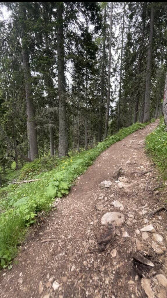
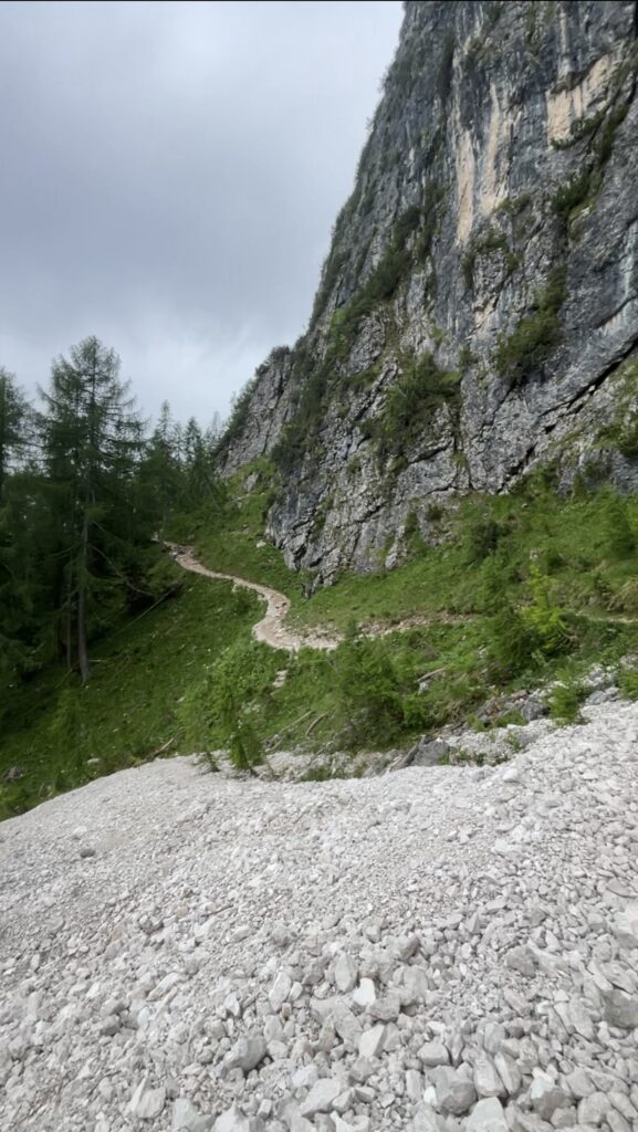
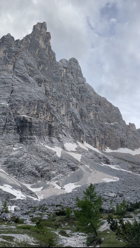
The trail to Lago di Sorapis begins at Passo Tre Croci (1,805 m) and immediately leads you into a mix of shaded forest, rocky mountain paths, and open stretches with sweeping Dolomite views.
The terrain isn’t technically difficult, but there are several sections where you’ll need to watch your footing, especially as the trail begins to contour along the rocky walls of Cima di Marcuoira.
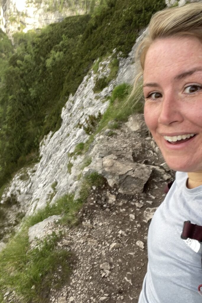
This is where the exposed portions begin. The path narrows significantly, with steep drop-offs and short ledges that require attention and confidence.
These sections are protected with cables, but they can still feel intimidating if you’re new to hiking in the Dolomites.
I mention this not to scare anyone, but because novice hikers often underestimate this trail. Awareness matters, and knowing what to expect makes the entire hike feel more manageable.
Starting Your Hike in the Afternoon
Since I started later in the afternoon, I had a very different trail experience than most hikers. As I was heading in, I passed a steady stream of people finishing their hike for the day—many of them giving me a few curious looks as they descended.
It felt a little strange at first, hiking in as everyone else was hiking out, but starting late turned out to be a choice I genuinely appreciated. The trail became quieter, the light softened across the valley, and I felt like I had the mountains entirely to myself.
These sections of the Lago di Sorapis Hike are completely manageable with proper hiking footwear and a steady, intentional pace—but you do need to stay focused and move carefully.
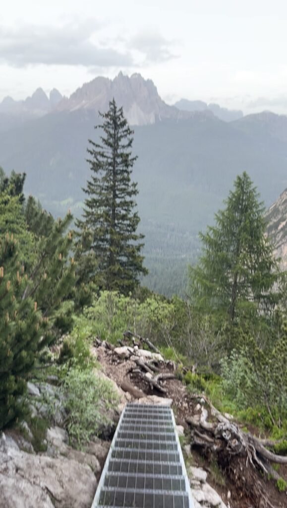
The Rusty Stairs of Lago Di Sorapis
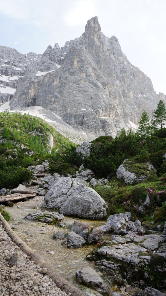
Midway through the Lago di Sorapis hike, the landscape opens up dramatically.
The forest gives way to wide views of towering Dolomite peaks and deep valleys—a moment that makes you stop and take it in, even if you’re focused on the trail.
Around this point, you’ll climb a set of rusty metal stairs. No matter the season, these stairs tend to be slick, so move slowly and place your feet carefully.
Not long after, you’ll reach a short section that requires full-body scrambling. It’s straightforward if you have hiking experience, but beginners might find it a little intimidating at first.
When I hiked this trail, a Polish family in front of me was wearing basic tennis shoes and really struggling for traction on the rocks.
And I’ll say this as plainly as possible: wear proper hiking footwear.
The Dolomites are not the place for casual sneakers. Good grip, ankle stability, and confidence underfoot make a massive difference in how safe—and enjoyable—this part of the trail feels.
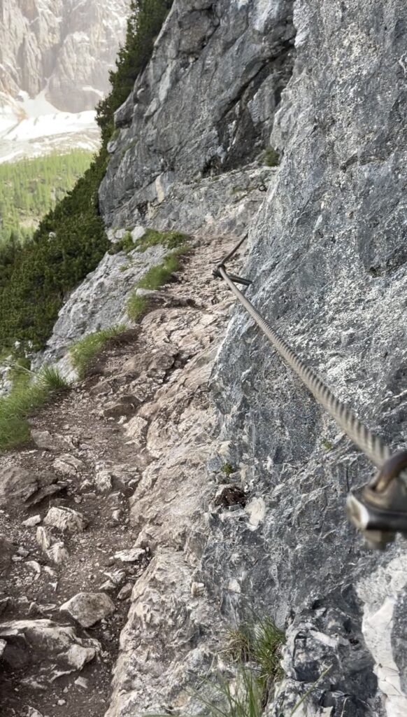
There’s a well-known exposed section on this trail—the one you’ve probably seen all over Facebook and Instagram.
This part of the Lago di Sorapis hike includes narrow ledges with steep drop-offs, steel cables for support, and a few wooden footpaths that connect one ledge to the next.
It looks dramatic online, and in person, it definitely gets your attention, but with proper footwear and steady footing, it’s completely manageable.
The “Whoa” Moment of Lago Di Sorapis
As you continue along these ledges, the landscape shifts again, and the first hint of that turquoise water appears through the trees.
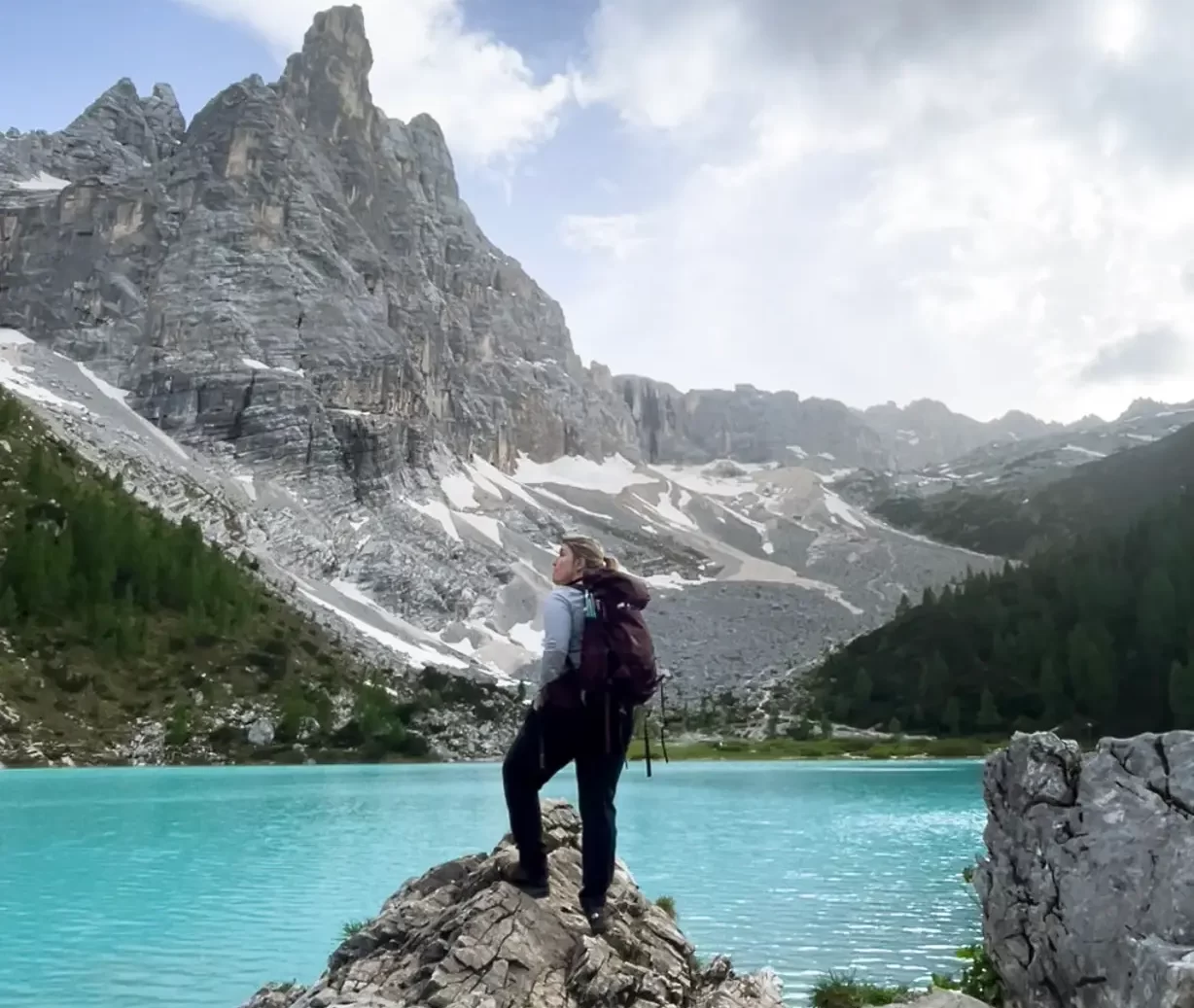
Approaching Lago di Sorapis for the first time is surreal. The lake’s milky blue color almost glows against the pale limestone and rugged peaks.
I’m willing to bet you’ll do exactly what I did: stop in your tracks and let out a very unfiltered “Whoa.” No photo prepares you for how blue the lake truly is.
There was a gentleman behind me who did the same thing, and we both laughed at our reaction.
Best Season to Hike Lago di Sorapis
Hiking Lago di Sorapis is very season-dependent, and the experience changes dramatically between June and October. Below is exactly what to expect during each window so you can plan with realistic expectations.
Mid-June – Early July: The Start of Hiking Season
This is when the trail finally becomes accessible after winter. Snow and ice have usually melted by June 15, though patches can linger depending on the year. The lake is at its fullest and bluest, the forests are lush, and temperatures are mild.
Crowds start to pick up quickly, so early morning starts are best. If you want the lake at its most stunning, this is one of the most reliable seasons.
July – Mid-September: Peak Season (and Peak Crowds)
This is the classic Dolomites summer season, and it’s short—roughly June 15 to September 15. The trail is fully open, the lake is bright turquoise, and the weather conditions are the most stable.
But this is also when the Lago di Sorapis trail is at its busiest.
Expect heavy foot traffic on narrow ledges, long lines at cable-protected sections, and a very crowded lakeshore by midday. If you hike during this period, prepare for:
- Early starts or very late-afternoon departures
- Limited parking at Passo Tre Croci
- Sharing the trail with large groups and guided tours
The lake is stunning, but solitude is rare in high summer.
Late September – October: Fewer Crowds, Lower Water Levels
Autumn offers cooler temperatures, golden light, and a more peaceful trail—but the lake itself often looks very different.
Recent years have shown significantly lower water levels in late September and October, and hikers in various Dolomites Facebook groups have reported the lake being extremely low or nearly empty.
You’ll still get a beautiful hike, but the iconic turquoise color is not guaranteed. Trails can also become slippery with early frost, and daylight hours shorten quickly.
Choose fall if you’re here for hiking and scenery. Choose summer if you’re here specifically for the lake’s famous color.
When Not to Hike Lago di Sorapis
Despite its popularity, Lago di Sorapis is not a year-round hike. Conditions can shift quickly in the Dolomites, and this trail becomes risky—sometimes dangerously so—outside the main summer window. Here are the situations when you should avoid it altogether.
Do Not Hike in Early Spring (April–Early June)
Snow, ice, and lingering avalanche risk make this trail unsafe before mid-June. The narrow ledges and cable-assisted sections become extremely slick, and even experienced hikers struggle to navigate these early-season hazards. Many rescues occur during this time because people underestimate the conditions.
Avoid Late Fall (Late October–November)
By late October, days are short, temperatures drop quickly, and ice begins to form on shaded parts of the trail. Water levels at Lago di Sorapis are also at their lowest, so the lake is often underwhelming. Combine that with unstable footing and a lack of daylight, and this becomes a high-risk period.
Do Not Attempt in Winter (December–March)
This is a hard no. Snowpack, ice coverage, avalanche danger, and difficult route-finding make the trail essentially inaccessible. The cables are often buried, the ledges are unsafe, and the trail is not maintained for winter hiking. Only expert alpinists with proper winter gear and training should be anywhere near this area—and even they rarely choose this route in winter.
Reconsider if Weather Is Unstable (Storms, Fog, or Heavy Rain)
The Dolomites are notorious for fast-changing weather. Avoid the trail if:
- Thunderstorms are forecasted
- Heavy rain has saturated the path
- Fog reduces visibility
- Winds are strong enough to make narrow sections unsafe
The cable-protected portions are especially dangerous when wet, and fog can make route-finding near the lake confusing. Please take this advice seriously, as there were a record number of incidents in the Dolomites last year.
Tips for Hiking to Lago di Sorapis
- Best season for Lago Di Sorapis: Late June through early October
- Start early in the morning to avoid crowds and ensure daylight on your return; if you aren’t doing the sunset hike
- Bring: Hiking boots, layers, snacks, water, a headlamp, and a downloaded offline map
- Avoid: Swimming in the lake—it’s strictly forbidden
- Respect the trail: Pack out everything you bring in
- Please don’t risk anything happening to you by not preparing yourself.

Hotels and Accommodations Near Lago di Sorapis
If you want easy access to the Passo Tre Croci trailhead, staying near Lago di Misurina or in Cortina d’Ampezzo is the smartest choice. I based myself at Hotel Sorapis, just over 6 km from the trailhead, and it was the perfect location for a relaxed, early start.
Booking places to stay near Sorapis can be kind of difficult if you don’t book months in advance.
B&B Hotel Passo Tre Croci Cortina
This hotel is located right next to the trailhead, making it the most convenient option for hiking Lago di Sorapis. It books up quickly during summer and on weekends, so reserve early. I’ve stayed here before—if you want the full breakdown, I’ve included it in my guide “Where to Stay in the Dolomites: My Favorite Hotels I Have Stayed At.”
Cortina Lodge – Stunning View R&R
A more upscale stay near Cortina d’Ampezzo, ideal if you want comfort, privacy, and sweeping views after a long day on the trail. Friends of mine stayed here during their Dolomites trip and absolutely loved it.
Use this map below to find a hotel that suites your needs:
Other Trails to Lago di Sorapis (For Experienced and Returning Hikers)
While the most popular route to Lago di Sorapis begins at Passo Tre Croci, there are several other trails that lead to the lake. These routes are less trafficked, more challenging, and better suited for hikers who want something beyond the standard out-and-back. If you’ve already hiked Sorapis once—or you’re confident on longer, more demanding Dolomites trails—these alternatives offer a completely different experience.
Always check Komoot for verified routes here, and PLEASE do not do anything risky; follow all signs you may see for closed trails. DO NOT be that hiker who has to get rescued.
1. Rifugio Vandelli Approach (Circular Routes)
If you want a bigger day out, multiple loop options include Rifugio Vandelli, the mountain hut perched near the lake. Some hikers circle the ridge systems to make a long loop, approaching the lake from behind the hut.
What to expect:
- Longer mileage
- Steeper ascents and descents
- Loose scree and sections that demand a strong footing
- Fewer people and a more alpine feel
This is not a beginner route, but it’s a rewarding option if you’re comfortable with route-finding and high-altitude terrain.
2. From Carbonin (Val di Landro / Schluderbach)
This lesser-known approach starts near Carbonin, between Dobbiaco and Cortina. It’s a quieter, wilder path that climbs steadily through forest and alpine meadows before joining the main trail network above the lake.
Why you might choose it:
- Fewer crowds
- A more remote feeling
- Sweeping views of the Cristallo Group
- Ideal for hikers looking for solitude
The elevation gain is more significant, so this is best for experienced hikers with good conditioning.
3. Circuit via Forcella Marcoira (For Very Experienced Hikers)
One of the most dramatic ways to reach Lago di Sorapis is by traversing Forcella Marcoira, a high saddle between jagged peaks. This route connects to the main Sorapis trail but includes steep scree, exposed sections, and terrain that often requires hands-on scrambling.
This route is best for you if:
- You have solid Dolomites experience
- You’re comfortable with exposure
- You want an adventurous, full-day outing
It is not recommended in early season or bad weather.
4. Multi-Day Options on the Alta Via Network
While not direct access routes, hikers doing sections of the Alta Via 3 or piecing together custom multi-day traverses often detour to Rifugio Vandelli. This is a fantastic option if you want to turn Sorapis into part of a larger Dolomites adventure.
Great for:
- Trekking enthusiasts
- Anyone preparing for longer routes like the AV1 or AV2
- Hikers who want Sorapis without the day-tripper crowds
Navigation Tips for Lago Di Sorapis
I used Komoot for this hike, and it worked flawlessly—until it didn’t. Cell service around Passo Tre Croci is patchy, and you cannot rely on having signal the entire way.
Before you start:
- Download your map for offline use
- Bring a paper map as backup
- Keep your phone on airplane mode to save battery
Use this link to get to the hike and save it in your Hikes!
You can even download the GPX file to save and use while offline.
Lago di Sorapis Trail: Frequently Asked Questions
At Passo Tre Croci, about 15 minutes from Cortina d’Ampezzo.
Yes, roadside parking is available, but it fills up quickly.
Moderate, with some rocky and narrow sections. Suitable for fit hikers with proper gear.
Rifugio Vandelli near the lake may be open during summer for food and restrooms.
Yes, but be mindful of rocky, narrow sections. Keep your dog leashed and bring water. I would really rethink bringing a dog with you though.
The signal is spotty. Download maps in advance.
Is Hiking to Lago di Sorapis Worth It?
Hiking to Lago di Sorapis is absolutely worth it—but it’s not for everyone.
This is one of the most popular hikes near Cortina d’Ampezzo for a reason. The turquoise lake is stunning, but the trail itself requires awareness, proper footwear, and a bit of patience, especially in peak season.
If you’re looking for one of the best hikes in the Dolomites and you’re willing to put in the effort, Lago di Sorapis delivers. Just don’t expect it to be easy or empty.
Contact
If you have any questions about the route or want to connect with me, check me out on Instagram @kimberlykepharttravels
PIN THIS POST!
Pin this post to save it for later, and check out my other Dolomites hiking guides for more inspiration.